
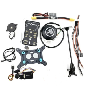
Description
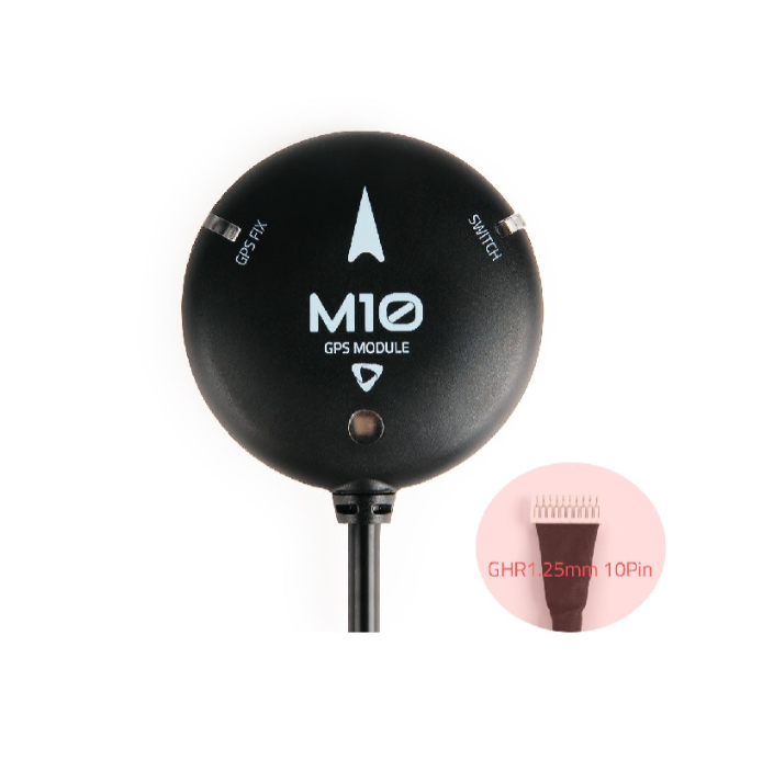
Holybro M10 GPS Module Standard GPS (GHR 1.25mm 10pin)
Holybro M10 GPS Module Standard GPS is a high-performance navigation solution designed for Pix32 and Pixhawk flight controllers. Leveraging the latest u-blox M10 GNSS receiver, it supports concurrent tracking of multiple satellite constellations, including GPS, Galileo, GLONASS, BeiDou, and QZSS, ensuring robust and accurate positioning data. This multi-constellation support enhances the module’s reliability and performance, making it suitable for various drone applications.
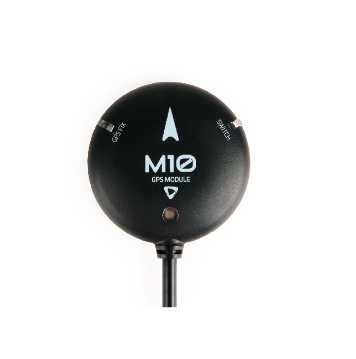
Equipped with the IST8310 digital compass, the Holybro M10 GPS Module provides precise heading information, crucial for stable flight and accurate navigation. The integrated tricolor LED indicator offers clear visual cues of GPS status, aiding in quick diagnostics and operational awareness. Additionally, the onboard buzzer and safety switch enhance user interface and safety during operation, providing audible alerts and manual control options.
Holybro M10 GPS features a high-gain 25x25mm ceramic patch antenna that delivers excellent performance and an omnidirectional radiation pattern, increasing flexibility for device installation. It also includes active circuitry for the ceramic patch antenna and a rechargeable backup battery for warm starts, ensuring continuous operation even after power cycles.
Designed for compatibility with popular flight control firmware, the Holybro M10 GPS Module supports PX4 1.14, ArduPilot 4.3, INAV 5.0.0, and Betaflight 4.3.0 or newer, ensuring versatility across various drone applications. Whether you’re engaged in aerial photography, surveying, or other UAV operations, this GPS module provides the precision and reliability needed for successful missions.
-
Holybro M10 GPS Module Standard GPS for Pix32 & Pixhawk – Advanced Multi-GNSS Solution
-
Reliable Navigation: Holybro M10 GPS Module for Pix32 & Pixhawk

🔧 Key Features:
- Holybro M10 GPS Module-Multi-Constellation GNSS Support: Simultaneous reception of GPS, Galileo, GLONASS, BeiDou, and QZSS for enhanced accuracy and reliability.
- Holybro M10 GPS Module-IST8310 Digital Compass: Provides precise heading information, crucial for stable flight and accurate navigation.
- Holybro M10 GPS Module-High-Gain 25x25mm Antenna: Offers excellent signal reception, even in challenging environments, ensuring continuous connectivity.
- Holybro M10 GPS Module-Integrated Buzzer & Safety Switch: Enhances user interface and safety during operation, providing audible alerts and manual control options.
- Holybro M10 GPS Module-Tri-Color LED Indicator: Clearly indicates GPS status, aiding in quick diagnostics and operational awareness.
- Holybro M10 GPS Module-Firmware Compatibility: Supports PX4 1.14, ArduPilot 4.3, INAV 5.0.0, and Betaflight 4.3.0 or newer, ensuring versatility across various drone applications.
📦 Package Includes:
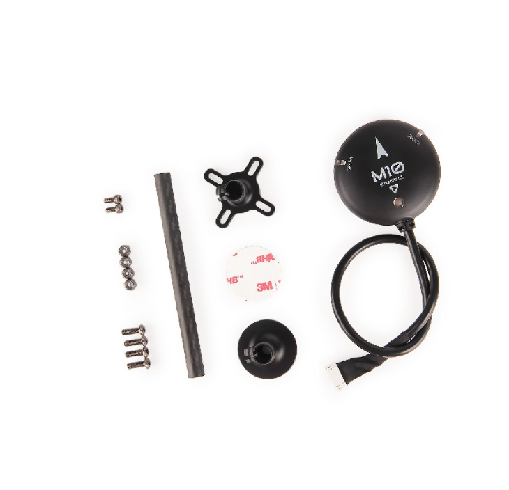
- 1x Holybro M10 GPS Module
- 1x Fixed Carbon Fiber GPS Mount
📐 Specifications
| Parameter | Details |
|---|---|
| GNSS Receiver | u-blox M10 |
| Compass | IST8310 |
| Output Protocol | UBX (u-blox), NMEA |
| Accuracy | 2.0m CEP |
| Navigation Update Rate | Up to 25 Hz (single GNSS), Up to 10 Hz (4 concurrent GNSS) |
| Baud Rate | 115200 |
| Input Voltage | 4.7 to 5.2V |
| Port Type | JST-GH-10P |
| Antenna | 25x25x4mm ceramic patch antenna |
| Power Consumption | Less than 200mA @ 5V |
| Operating Temperature | -40°C to 80°C |
| Dimensions | φ50 x 14.4 mm |
| Weight | 32g |
| Cable Length | 26 cm |
“For those seeking compatible drones, explore our range of NIMBUS PRO X Camera Drones and the DJI Mini Series to find the perfect match for your navigation needs.”
- Agricultural Drones:
“For precision agriculture tasks, our NIMBUS 10L Hexacopter Agricultural Spraying Drone offers efficient crop monitoring and spraying capabilities.”loftyagrotech.com
- Aerial Photography and Mapping:
- “Capture high-quality aerial images with the DJI Mini 3 Pro Drone Camera With Fly More Kit, known for its extended flight time and advanced imaging features.”loftyagrotech.com+7loftyagrotech.com+7loftyagrotech.com+7
TO KNOW MORE
-
1. Firmware Compatibility:
When mentioning firmware support, provide links to official documentation for user reference:
“The Holybro M10 GPS Module supports various flight control firmware, including PX4 1.14, ArduPilot 4.3, INAV 5.0.0, and Betaflight 4.3.0.”
2. Pixhawk Resources:
For readers interested in learning more about Pixhawk systems:
“For comprehensive information on Pixhawk flight controllers, visit the Pixhawk Official Website.”
3. Tutorial Videos:
To assist users in setup and configuration:
“Watch this tutorial video on how to connect and configure dual Holybro M10 GPS Module with a Pixhawk flight controller.”
🚁 Applications in Drone Technology
1. Drone Navigation and Positioning
The Holybro M10 GPS Module enables drones to maintain stable flight paths, return-to-home (RTH) functions, and follow predefined waypoints by providing accurate positioning data. This is particularly beneficial in environments where GPS signals are essential for navigation.
2. On-Screen Display (OSD) Integration
With its fixed baud rate and compatibility with Cleanflight and Betaflight controllers, the Holybro M10 GPS Module facilitates the integration of GPS data into the drone’s on-screen display. Pilots can monitor real-time information such as speed, altitude, and flight time, enhancing situational awareness during flight.
3. Racing Drones
The compact size and lightweight design of the Holybro M10 GPS Module make it an excellent choice for racing drones. In racing scenarios, precise positioning and minimal weight are critical for optimal performance.
4. Agricultural Drones
In precision agriculture, drones equipped with GPS modules like the Holybro M10 GPS Module can perform tasks such as crop monitoring, field mapping, and automated spraying. Accurate GPS data ensures that these tasks are carried out efficiently and within specified boundaries.
5. Aerial Photography and Mapping
For aerial photography and mapping applications, precise georeferencing is essential. The Holybro M10 GPS Module provides accurate location data, enabling the creation of detailed maps and high-quality aerial images with correct spatial references.
6. Surveying and Inspection
Drones equipped with GPS modules are increasingly used for surveying and inspecting infrastructure such as power lines, bridges, and pipelines. The Holybro M10 GPS Module ensures that the drone’s position is accurately tracked, allowing for precise data collection and analysis.
7. Search and Rescue Operations
In search and rescue missions, drones can cover large areas quickly. The Holybro M10 GPS Module aids in mapping out search grids and tracking the drone’s location, improving the efficiency and effectiveness of these operations.
8. Environmental Monitoring
Drones equipped with GPS modules can be used to monitor environmental conditions such as forest health, wildlife populations, and pollution levels. The M10 GPS Module provides accurate location data, ensuring that monitoring activities are conducted in the correct areas.
9. Educational and Research Purposes
Educational institutions and research organizations use drones for various studies, including atmospheric research, wildlife tracking, and geographical surveys. The M10 GPS Module offers a cost-effective solution for integrating GPS functionality into these drone applications.
10. Urban Planning and Development
In urban planning, drones equipped with GPS modules can conduct aerial surveys to assess land use, infrastructure development, and urban sprawl. The M10 GPS Module ensures that the drone’s position is accurately tracked during these surveys.
🛡️ Warranty Information
This product is covered by a 3-month standard supplier warranty from the time of delivery against manufacturing defects only. Replacement will be provided for manufacturing defects.
Warranty void if:
-
Product is subjected to misuse, tampering, static discharge, accident, water or fire damage, use of chemicals, or soldered/altered in any way.


Reviews
There are no reviews yet.